This is a subscription only section
Want to read more? It's only €10/year.
No account yet? Just Create an account first and head to the shop
| ICAO Code | SCVM/KNA |
| Last Validated | Mar 2010 |
| City | Viña del Mar |
| Position | 32°56'59"S 071°28'43"W |
| Runway(s) | 05/23 |
| Elevation | 461 ft |
Viña del Mar is the prime naval aviation base of Chile. It also has a small civil area.
The airfield is on top of a hill and has a east-west runway. The Chilean navy resides on the north west part whereas the civil ramp is on the south west side. The aero club uses a small ramp on the south side.
Although the airfield is known as Viña del Mar it is actually just east of Concón, north of Viña del Mar along highway no.6. The base is called Torquemada.
Sometimes naval aircraft use the civil ramp to perform engine runs. This shot was taken from the airfield access road, actually somehwat west of spot 2. (March 2010, Erwin van Dijkman)

If you are lucky, the flying helicopters turn tight passing the civil terminal. Back light the whole day at spot 2 though, it is the southern hemisphere remember... (March 2010, Erwin van Dijkman)
| 121.850 | Ground |
| 118.400 | Tower |
| 128.100 | Santiago Approach |
| Escuadrón Embarcado | SH-32 (AS332B, AS532SC), HH-65 (AS365N) |
| Escuela de Aviación Naval (EAN) | PC-7 |
| HA-1 | SH-32 (AS332B, AS532SC), HH-65 (AS365N) |
| HU-1 | Bell 206B, UH-05 (Bo105CBS) |
| VC-1 | C212-100, O-2A |
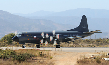
| VP-1 | EMB111AN, C295MPA (o/o), P-3ACH, UP-3A |
| VT-1/VA-1 | PC-7 (on loan from EAN) |
| Club Aéro Naval | Ce150M, Ce152, CeR172/172M, Ce182, PA-18 |
| 218 | PC-7 (entrance road) |
| 01 | Bell 47G (gate, pole mounted) |
| 104 | C-45 (gate) |
| 261 | EMB111AN (gate) |
| 214 | PC-7 (gate, pole mounted) |
| 401 | UP-3A (gate) |
| 121 | R4D-5 (gate) |
| 107 | EMB110CN |
| 201 | T-34B |
| Chile - Air Force |
| Chile - Army |
| Chile - Navy |
| Chile - Military Police |
| Chile - Police |
| Antofagasta - Cerro Moreno Intl | |
| Concepción - Carriel Sur Intl | |
| Punta Arenas - Pres. Carlos Ibañez del Campo | |
| Quintero | |
| Rancagua - De la Independencia | |
| Santiago - A.M.Benitez Intl (Pudahuel) | |
| Santiago - El Bosque | |
| Santiago - Eulogio Sánchez (Tobalaba) | |
| Santiago - Municipal de Vitacura | |
| Talca - Panguilemo | |
| Viña del Mar (Torquemada) |
As a member you get access to all our
premium content and benefits learn more