This is a subscription only section
Want to read more? It's only €10/year.
No account yet? Just Create an account first and head to the shop
| ICAO Code | EDHK/KEL |
| Last Validated | |
| City | Kiel |
| Position | 54°22'46"N 010°08'43"E |
| Runway(s) | 08/26, 08/26 (grass) |
| Elevation | 101 ft |
This former German navy base, once home to the fleet of Sea Kings, is located north of the city of Kiel. When MFG5 left in November 2012, this became the civilian Airport Kiel that accomodates mostly general aviation. An interesting local operator is QinetiQ, providing aerial target services with PC-9s and PC-12s from here. During the yearly Kieler Woche (Week of Kiel), military rotorcraft tend to visit this small airport from their ships. The Kieler Woche is a major public event around a regatta, and coincides with the annual Baltops exercise. Thus, both German and foreign navy ships will be in the area, often carrying helicopters or Ospreys. The spotting conditions, both for photography and serial reading, are very scarce though.
Since the closure of the heliport, the oval-like area is what the airport consists of. A taxiway runs around the east-west runway and the active facilities are in the north. Some hangars and the old control tower remain in the south, and most of the heliport infrastructure is still there in the east along the water. Parts of this are open to the public, mainly for pedestrians, but the area is to be sacrificed for urban purposes. All of the field is surrounded by roads or private property.
The field is right along the B503, out of Kiel city to the north. Take the second exit after the Nord-Ostsee-Kanal bridge, the Boelckestraße leads directly to the entrance.
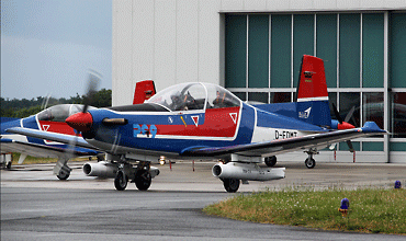
Before QinetiQ, EIS Aircraft operated the PC-9s here. Helwin Scharn photographed this pair through the fence at spot 1.
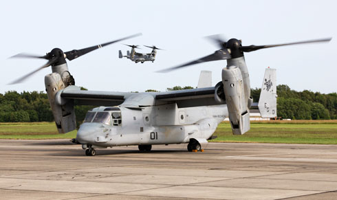
Ospreys visiting during the Kieler Woche, seen from the restaurant terrace at spot 1. (Frank Noort)
| 119.980 | Info |
| 136.225 | Bremen Radar |
| Kiel Aviation | Ce172, P68 |
| QinetiQ | PC-9, PC-12 |
| Airport Kiel | Official site of the civil airport |
| German Air Force |
| German Army |
| German Navy |
| Ansbach/Katterbach AHP | |
| Berlin/Tegel - CLOSED | |
| Braunschweig-Wolfsburg | |
| Bremen/Neuenlanderfeld | |
| Büchel | |
| Bückeburg | |
| Celle | |
| Coleman Barracks - CLOSED | |
| Diepholz | |
| Donauwörth Heliport | |
| Dresden | |
| Düsseldorf | |
| Emden | |
| Fassberg | |
| Frankfurt/Hahn | |
| Frankfurt/Main | |
| Fritzlar | |
| Geilenkirchen | |
| Hamburg/Finkenwerder | |
| Hamburg/Fuhlsbüttel | |
| Hannover/Langenhagen | |
| Hohn | |
| Holzdorf | |
| Illesheim AHP | |
| Ingolstadt/Manching | |
| Jever - CLOSED | |
| Kiel/Holtenau | |
| Köln-Bonn | |
| Laage (Rostock) | |
| Landsberg - CLOSED | |
| Landstuhl - CLOSED | |
| Laupheim | |
| Lechfeld | |
| Leipzig/Halle | |
| Mendig | |
| Mönchengladbach (Düsseldorf) | |
| München/Franz Josef Strauss | |
| Münster-Osnabrück | |
| Neuburg | |
| Niederstetten | |
| Nordholz | |
| Nörvenich | |
| Nürnberg | |
| Ramstein | |
| Rheine/Bentlage - CLOSED | |
| Roth | |
| Saarbrücken (Ensheim) | |
| Schleswig (Jagel) | |
| Spangdahlem | |
| Stuttgart | |
| Weeze | |
| Wiesbaden AAF | |
| Wittmundhafen | |
| Wunstorf |
As a member you get access to all our
premium content and benefits learn more