This is a subscription only section
Want to read more? It's only €10/year.
No account yet? Just Create an account first and head to the shop
| ICAO Code | KSCK/SCK |
| Last Validated | 12-2022 |
| City | Stockton |
| Position | 37°53'39"N 121°14'18"W |
| Runway(s) | 11L/29R, 11R/29L |
| Elevation | 33 ft |
The Stockton Metropolitan Airport is located on the Southern boundary of the city of Stockton in the heart of California's central valley. The Airport is conveniently located between two major north-south thoroughfares; Interstate 5, 1.5 miles to the West, and State Highway 99, which borders the airport on the East side. In the months preceding World War II, the U.S. Army entered into the first of many lease agreements with the City of Stockton (on 15 August 1940) to build and operate an Army training facility at Stockton Municipal Airport. In October 1946 Stockton AAF was declared surplus. The City of Stockton and the County of San Joaquin resumed operating the Stockton Municipal Airport on 16 December 1946 under a joint license. Nowadays it has a new large terminal, many hangars for Business and general Aviation and a large apron for the California Army National Guard.
The airport has two runways and most of the aprons on the south side. The Army apron is on the southeast side.
If you approaching from the North on Highway 99: Take the Arch Rd. exit and bear right onto Arch-Airport Rd. and follow it westbound for approximately 1 1/2 miles. Notice the airport is on your left. Just before the intersection of Arch-Airport Rd. and Airport Way you will see a left turn lane for Ruggles Frontage Rd. If you are approaching from the South on Highway 99: Take the Arch Rd. exit and follow the off-ramp westbound (left) under the highway. Once past Highway 99 the Road name changes to Arch-Airport Rd. Follow it Westbound for approximately 1 1/2 miles. Notice the airport is on your left. Just before the intersection of Arch-Airport Rd. and Airport Way you will see a left turn lane for Ruggles Frontage Rd. Turn left onto Ruggles Rd.
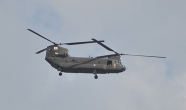
Wim Sonneveld was here and took a pictures of a Chinook from spot 6, so you can do the same!
| 121.900 | Ground |
| 120.300/239.000 | Tower |
| 125.100 | Norcal Dep. |
| 123.850/124.800/125.100 | Norcal App |
| 118.250 | ATIS |
| 139.400/356.900 | ArNG Ops |
| B/1-126th AVN (HH) CA ArNG | CH-47F |
| A(-)/3-140th AVN (SS) CA ArNG | UH-72A |
| Allegiant Airlines | A319, A320 |
| various | Stockton Field Museum |
| 70-15987 | AH-1S, preserved at US Army apron, spot 3 |
| 89-00177 | CH-47D, preserved at US Army apron, spot 3 |
| Airport Diagram | Airport Diagram with runways and taxiways |
| Barstow-Daggett | |
| Edwards AFB | |
| El Centro NAF | |
| Fresno Yosemite Intl | |
| Hemet - Ryan Field | |
| Imperial Beach NOLF | |
| Lemoore NAS - Reeves Field | |
| March JARB | |
| Miramar MCAS | |
| Moffett Federal Airfield | |
| North Island NAS | |
| Palmdale Regional - Air Force Plant 42 | |
| Point Mugu NAS | |
| Sacramento - Mather | |
| San Francisco - Intl | |
| Santa Monica - Municipal | |
| Stockton Metropolitan | |
| Travis AFB | |
| Van Nuys |
As a member you get access to all our
premium content and benefits learn more