This is a subscription only section
Want to read more? It's only €10/year.
No account yet? Just Create an account first and head to the shop
| ICAO Code | KVGT/VGT |
| Last Validated | 01-2023 |
| City | Las Vegas |
| Position | 36°12'38"N 115°11'40"W |
| Runway(s) | 07/25, 12L/30R, 12R/30L |
| Elevation | 2205 ft |
North Las Vegas Airport was created by aviation enthusiasts Verald "Bud" Barrett and J.M. and Florence Murphy, who opened the airfield as Sky Haven Airport on December 7, 1941. The opening celebration was interrupted by news of the air raid at Pearl Harbor, and a scheduled flying demonstration was cancelled. The small airport became successful during World War II when it was used by general aviation flyers and pilots from the Las Vegas Army Air Base for off-duty flying. In the early 1960s, the runways were paved, a new administration building and restaurant were built, and the 40-unit Sky Rider Motel, complete with an airplane-shaped swimming pool, opened for business. Clark County purchased it in 1987 and made a considerable investment to upgrade the airport, including a new 15,600-square-foot terminal building completed in 1992. North Las Vegas Airport is home to nearly 700 based aircraft and 25 commercial businesses. General aviation activity, flight instruction and a sightseeing airline makes North Las Vegas one of the busiest airports in the country. Many helicopter operators, including Las Vegas Metropolitan Police Department and the US Army, also use the airport. Furthermore Blue Air Training Corp has its base here.
The airport is quite large for a GA airport, with two parallel runways running NW-SE and one W-E runway. To the east is the ATC Tower and a large apron primary used for aircraft storage. To the north are hangars which include the Cheyenne Air Center hangar which is also used by the US Army helicopters. To the west are the FBOs and the GA hangars as well as the hangar of the Blue Air Training Corp and the Civil Air Patrol.
From Henderson airport or Las Vegas, drive towards the Interstate 15 northbound. Take exit 42A towards the highway 95 direction Reno. On the US-95 keep right onto US-95 Business/Rancho Drive. Now take the right exit towards N Decatur Road to arrive at spot 1.
Parked at spot 2, when elevated by your pickup truck or some steps, you can take these shots of the Blue Air aircraft here (spot 2, 12 december 2022, Piet Luijken)
Near the terminal, there are two parking areas which give you views onto the apron, This shot was taken from the left parking. (spot 2, 11 november 2016, Joost de Wit)
| 124.000 | Clearance Delivery |
| 121.700 | Ground |
| 125.700 / 360.750 | Tower |
| 119.150 | Tower (RWY 12L/30R OPS) |
| 119.400 | Departure |
| 119.400 / 118.125 | Approach |
| 118.050 | ATIS |
| Det.1 B/3-140th AVN NV ARNG (S&S) | UH-72A/UH-72B |
| Det.1 D/3-140th AVN NV ARNG (AA) | UH-72A |
| LVMP Air Support Unit | H145 |
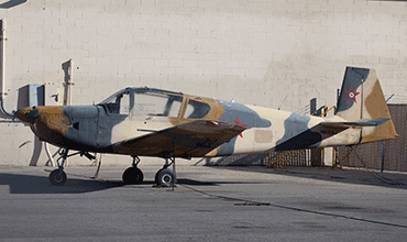
| Blue Air Training Corp. | IAR823/PC-9A |
| FAA airport diagram | FAA airport diagram with all taxiways, aprons etc. |
| Las Vegas - McCarran Intl | |
| Nellis AFB | |
| North Las Vegas |
As a member you get access to all our
premium content and benefits learn more