This is a subscription only section
Want to read more? It's only €10/year.
No account yet? Just Create an account first and head to the shop
This is a subscription only section
Want to read more? It's only €10/year.
| ICAO Code | KMHR/MHR |
| Last Validated | 03-2023 |
| City | Sacramento |
| Position | 38°33'19"N 121°17'50"W |
| Runway(s) | 04L/22R, 04R/22L |
| Elevation | 98 ft |
Located 20 minutes from downtown Sacramento and specializing in general aviation and cargo aviation, Mather Airport (MHR) is conveniently located along US 50. The name, “Mather Field,” was inspired by Carl Mather, a Second Lieutenant in the Army Signal Corps. Lieutenant Mather was tragically killed on January 25, 1918 at the age of 16. During the war, Sacramento’s Liberty Iron Works in North Sacramento produced Curtiss JN-4 aircraft. Mather Field was closed in 1923 after the armistice agreement halted World War I and ended pilot training at Mather Field. Remaining personnel at Mather Field were sent to bases in other states. Prior to entering World War II, the US government rebuilt Mather Field and by 1941 the air base was fully activated. Mather was used for pilot, navigator, observer, and bombardier training throughout the war and served as a strategic stopover location for troops and aircraft departing for or returning from combat duty in the Pacific. In 1958, a Strategic Air Command B-52 wing was assigned to the base and was deactivated in 1989. USAF closed the base in 1993. Taking advantage of the former Air Force Base’s ample ramp space and generous runway, UPS moved their operation from Sacramento International Airport to Mather. In 2006, Mather hosted the inaugural California Capital Airshow. It was the first civilian-run airshow in Sacramento history and featured the US Navy Blue Angels and attracted more than 100,000 people during the two-day event. Curently, the airshow continues to attract aviation enthusiasts to Mather Airport.
The airport has two runways in a northeast-southwest direction. all aprons and hangars are to the north of these runways. Hangars from left to right are for CDF (California Fire Department), UPS, Mather Aviation and California Army National Guard.
Sacramento/Mather airport is located south of the Route 50 El Dorado Freeway. Take the exit towards Bradshaw road and follow this road until you can turn left onto Old Placerville road. The airfield is now at your right. Take the exit to the right onto Macready Avenue to arrive onto the airport.
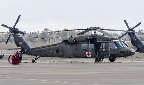
Frits Jongerman photographed this resident UH-60 from spot 2. This is also where the preserved UH-1 is on display along the road.
| 121.850 / 307.900 | Clear.Del. & Ground |
| 120.650 / 282.250 | Tower |
| 127.400 / 317.500 | NORCAL Departure/Approach |
| 122.950 | UNICOM |
| 118.325 | ATIS |
| MILITARY OPERATORS | |
| Det.1/F/2-135th AVN CA ArNG | UH-60A |
| C/1-168th AVN CA ArNG | UH-60L, HH-60L |
| A/3-140th AVN CA ArNG | OH-58A+/C |
| Det. 2 D/3-140th AVN CA ArNG | UH-72A |
| OSACOM det.32 | U-12U |
| CIVIL OPERATORS | |
| UPS | various |
| CDF | various |
| 74-22375 | UH-1H at spot 2 |
| Mather Airport | Website of Mather Airport by SAC. |
| Barstow-Daggett | |
| Edwards AFB | |
| El Centro NAF | |
| Fresno Yosemite Intl | |
| Hemet - Ryan Field | |
| Imperial Beach NOLF | |
| Lemoore NAS - Reeves Field | |
| March JARB | |
| Miramar MCAS | |
| Moffett Federal Airfield | |
| North Island NAS | |
| Palmdale Regional - Air Force Plant 42 | |
| Point Mugu NAS | |
| Sacramento - Mather | |
| San Francisco - Intl | |
| Santa Monica - Municipal | |
| Stockton Metropolitan | |
| Travis AFB | |
| Van Nuys |
As a member you get access to all our
premium content and benefits learn more