This is a subscription only section
Want to read more? It's only €10/year.
No account yet? Just Create an account first and head to the shop
| ICAO Code | EHDL/QAR |
| Last Validated | 03-2012 |
| City | Arnhem |
| Position | 52°03'38"N 005°52'23"E |
| Runway(s) | 01/19 |
| Elevation | 158 ft |
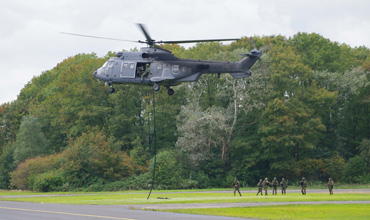
The former Air Base Deelen is located some 5 km north of Arnhem and 3 km west of the A50 motorway, close to the large gliding site Terlet. Air Base Deelen was founded in 1913 as a base for border patrol missions. When the Netherlands surrendered to Germany in World War II, the Luftwaffe started using the field, significantly expanding and upgrading the base. In 1950, the decision was made to restore Deelen back to an operational air base. Reconnaissance and training aircraft were stationed at Deelen in 1951. For the relatively short time of only five years Deelen was in use for jet-operations (1957-1962: RF-84F Thunderflash). But noise abatement measures resulted in de return of various light aircraft and helicopters. In 1995 the remaining two helicopter squadrons were transferred to Soesterberg. Today Deelen is still in use as a military helicopter training location. Because of the nearby army barracks, operations with the Dutch Air Assault Brigade often take place at Deelen, particularly when the use of helicopters from the Dutch Helicopter Command is required for these operations. Following the closure of Soesterberg in 2008, the aerodrome of Deelen was refurbished to house short term deployments from Gilze Rijen. These deployments may include one or more CH-47, AS532, AH-64D, NH-90 or Alouette 3 helicopters. These types of helicopters can also be seen during simulated emergency landings or during a night vision goggles training flight at dusk.
Additionally and mainly during the summer seasons, the flights of the local glider club may include the use of a tug-aircraft such as a Husky or a Pawnee.
The size of Deelen exceeds the ones of any other military airbase in the Netherlands. This as a result of the extensions that have been carried out during the German occupation during WW2. The remains of this occupation still can be seen at many locations in the surroundings of the former WW2 airbase (barracks, bunkers, hangars, taxiways). During war time Deelen had three concrete runways of which only the north/south one was adapted to NATO standards in the late 1950s. Because of the large size of the airbase there are no possibilities to approach the runway from the outside of the aerodrome. But ample views of taxiways and platforms can be found, mainly on the east side of the aerodrome.
Unfortunately the public transport system is inconvenient to get to Deelen. Only a school bus service is available between Arnhem and Hoenderloo. So during the weekends no public transport is available. By car the aerodrome of Deelen can be found when driving along the Hoenderloseweg. This road originates north from the Koningsweg on the east side of the village of Schaarsbergen. Parking along the Hoenderloseweg is not allowed, but for tourists visiting the Deelerwoud a small parking area is available, close to the Museum Vliegbasis Deelen.
Gerben Tornij took this picture from spot 5, from the Veteranenbos, after a firm walk.

Spot 3 is the place to make these kind of shots, as shown by Gerben Tornij.
| 312.400 / 129.930 | Tower |
| 399.725 / 123.580 | RAPCON West |
| 259.250 / 128.355 | Dutch Mil |
| Deelen Gliding Club | various |
| NX537/G | Auster AOP3, at Vlb Deelen Museum, spot 4. |
| FR31 | RF-84F, as P-7, at Oranjekazerne, spot 7. |
| Deelen Museum | Website of the Vlb Deelen Museum |
| Museum garderegiment Grenadiers en Jagers | Website of the Museum at spot 7 |
| Royal Netherlands Air Force/Navy |
| Coast Guard Netherlands |
| Ameland | |
| Amsterdam - Schiphol | |
| Budel (Kempen Airport) | |
| De Peel | |
| Deelen | |
| Den Helder/De Kooy | |
| Eindhoven | |
| Gilze-Rijen | |
| Groningen/Eelde | |
| Hilversum | |
| Hoogeveen | |
| Leeuwarden | |
| Lelystad | |
| Maastricht-Aachen | |
| Midden-Zeeland | |
| Rotterdam-The Hague | |
| Soesterberg - CLOSED | |
| Teuge | |
| Texel | |
| Twente | |
| Valkenburg - CLOSED | |
| Volkel | |
| Woensdrecht |
As a member you get access to all our
premium content and benefits learn more